ABOUT DSCOVR
The Deep Space Climate Observatory, or DSCOVR maintains the nation’s real-time solar wind monitoring capabilities by giving advanced warning of extreme emissions from the sun(known as the coronal Mass Ejections of CMEs) , which are critical to the accuracy and lead time of NOAA’s space weather alerts and forecasts. Without timely and accurate warnings, space weather events—like geomagnetic storms can affect power grids, communications systems, and satellites close to Earth. The DSCOVR mission succeeded NASA’s Advanced Composition Explorer’s (ACE) role in supporting solar wind alerts and warnings from the Lagrange point 1( L1 orbit), which is the neutral gravity point between the Earth and Sun, approximately one million miles from Earth.
Location: The DSCOVR mission succeeded NASA’s Advanced Composition Explorer’s (ACE) role in supporting solar wind alerts and warnings from the Lagrange point 1( L1 orbit), which is the neutral gravity point between the Earth and Sun, approximately one million miles from Earth
Why L1 orbit?? L1 is a good position from which to monitor the Sun, because the constant stream of particles from the Sun (the solar wind) reaches L1 up to an hour before reaching Earth. From this position, DSCOVR can typically provide 15- to 60-minute advanced warning before a storm of particles and magnetic field, known as a coronal mass ejection (or CME), reaches Earth. DSCOVR data also helps improve predictions of geomagnetic storm impact locations. Our national security and economic well-being, which depend on advanced technologies, are at risk without these advanced warnings.
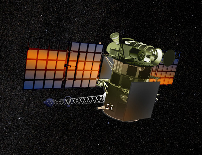
About the structure: DSCOVR was approximately 570 kg at launch and has dimensions of 54 by 72 inches. The spacecraft bus is equipped with two deployable solar arrays, a propulsion module, boom, and high-gain antenna.
INSTRUMENTS ONBOARD
About the structure:
DSCOVR was approximately 570 kg at launch and has dimensions of 54 by 72 inches. The spacecraft bus is equipped with two deployable solar arrays, a propulsion module, boom, and high-gain antenna.
Enhanced Polychromatic Imaging Camera (EPIC): The Earth Polychromatic Imaging Camera (EPIC) is an imager that provides global spectral images of the entire sunlit face of Earth, as viewed from an orbit around Lagrange point 1 (L1). EPIC is able to view the entire sunlit Earth from sunrise to sunset at an almost constant scattering angle between 165–178°. This scattering angle has minimal overlap with other satellites’ scattering angles. EPIC’s observations from the L1 position will provide a unique angular perspective and can be combined with other measurements to obtain particle shape, phase selection, optical depth, 3-D effects and stereo heights.
Imagery from EPIC will be used in science applications to measure ozone amounts, aerosol amounts, cloud height and phase, vegetation properties, hotspot land properties (a view of the land from angles where shadows are a minimum) and UV radiation estimates at Earth’s surface. Expected data products include: total ozone column, aerosol index, aerosol optical thickness, aerosol height, cloud fraction, cloud height, surface albedo, vegetation index, and Leaf Area Index and RGB colour image of the Earth’s sunlit surface.
PLASMA-MAGNETOMETER (Plas-Mag):
The Plasma-Magnetometer (PlasMag) measures solar wind activity to provide highly accurate and rapid warning of geomagnetic storms with lead times of up to one hour. The PlasMag instrument suite is a comprehensive science and space weather package that includes a fluxgate vector magnetometer, a Faraday Cup solar wind positive ion detector and a top-hat electron electrostatic analyser. This instrument cluster provides high time resolution measurements in real time and represents the next generation of solar wind monitors. The PlasMag will measure the magnetic field and the velocity distribution functions of the electron, proton and alpha particles (Helium nuclei) of solar wind with higher time resolution than existing instruments. The PlasMag was developed at NASA’s Goddard Space Flight Centre (GSFC) and the Massachusetts Institute of Technology (MIT) and optimized for small size, low power, simplicity and a dynamic range.
Measurements of solar wind are central to better determining how solar events affect Earth and its near-space environment, and will help the National Weather Service Space Weather Prediction Centre issue warnings for spacecraft and manned space flights. This instrument will help monitor solar weather to provide early warnings of solar events that may cause damage to power grids and satellites, and impact GPS and communications. The PlasMag suite of instruments will provide the information needed to issue warnings to protect electrical equipment on Earth and satellites in orbit.
NATIONAL INSTITUTE OF STANDARDS & TECHNOLOGY ADVANCED RADIOMETER (NISTAR)
NISTAR is a cavity radiometer designed to measure the absolute, spectrally integrated irradiance reflected and emitted from the entire sunlit face of the Earth, as viewed from an orbit around the Lagrange point 1 (L1) . Because Earth is not an isotropically reflecting object, the uneven distribution of land, ocean and ice on the surface and the continually changing cloud cover, vegetation, ice and snow make modelling the radiant energy emitted and reflected by Earth difficult. Nevertheless, we can accurately measure radiances over a critical angle range important for understanding Earth’s total radiant flux. NISTAR will be the first instrument capable of providing continual measurements over this angle range for the entire Earth. NISTAR was designed and built between 1999 and 2001 by Ball Aerospace and Technology Corporation and the NIST Optical Technology Division, in conjunction with the Scripps Institute of Oceanography and NASA, as part of the DSCOVR mission. The instrument consists of four detectors, three electrical-substitution active cavity radiometers and a photodiode, and several band defining optical filters that can be used with any of the detectors. In 2010 and 2013, the NISTAR instrument was calibrated against a portable version of the NIST SIRCUS (Spectral Irradiance and Radiance Responsively Calibrations using Uniform Sources) facility
The energy balance measurement and accuracy of the measurement will improve our understanding of the effects of changes to Earth’s radiation budget caused by human activities and natural phenomena. This information can be used for climate science applications. The data collected by NISTAR on Earth’s albedo, incoming short- and long-wave radiation, and outgoing long-wave radiation has never been measured from this position before. DSCOVR’s location at the L1 observing position permits long integration times because no scanning is required. Radiometric accuracy of 0.1–1.5% (varies with band) is expected, which is up to a 10-fold improvement in accuracy over current Earth-orbiting satellite data.
OUTCOMES
-
A year after returning it’s first image, NASA’s EPIC camera, aboard NOAA’s DSCOVR satellite, shows us an entire year from one million miles away using NASA’s Earth Polychromatic Imaging Camera (EPIC), a four megapixel CCD camera and telescope, aboard NOAA’s DSCOVR satellite. EPIC takes a new picture every two hours, revealing how the planet would look to human eyes, capturing the ever-changing motion of clouds and weather systems and the fixed features of Earth such as deserts, forests and the distinct blues of different seas. The camera has now recorded a full year of life on Earth from its orbit, seen here.
-
Real-time data from DSCOVR and space weather forecasts are now available through the Space Weather Prediction Center. An archive of DSCOVR data is also accessible to users, who will be able to visualize and download the data.
-
Faraday Cup Flight Performance Optimization.
-
NASA and NOAA (SWPC and OSPO) are actively monitoring Faraday Cup behavior in various solar wind conditions, and developing or updating flight software solutions to optimize the instrument behavior. The most recent modification was performed in August 2020, and additional work is ongoing.
From a Million Miles Away, NASA Camera Shows Moon Crossing Face of Earth, August 5, 2015
-
A NASA camera aboard the Deep Space Climate Observatory (DSCOVR) satellite captured a unique view of the moon as it moved in front of the sunlit side of Earth last month. The series of test images shows the fully illuminated “dark side” of the moon that is never visible from Earth.
-
The images were captured by NASA’s Earth Polychromatic Imaging Camera (EPIC), a four megapixel CCD camera and telescope on the DSCOVR satellite orbiting 1 million miles from Earth. From its position between the sun and Earth, DSCOVR conducts its primary mission of real-time solar wind monitoring for the National Oceanic and Atmospheric Administration (NOAA).